Ecosystem Diversity
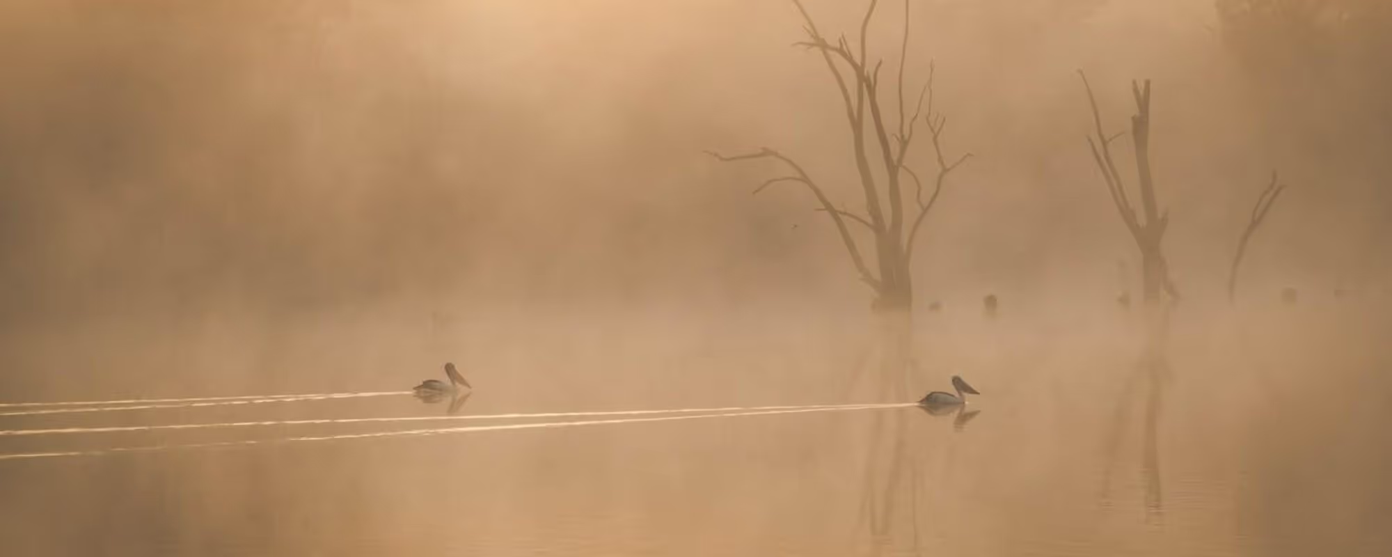
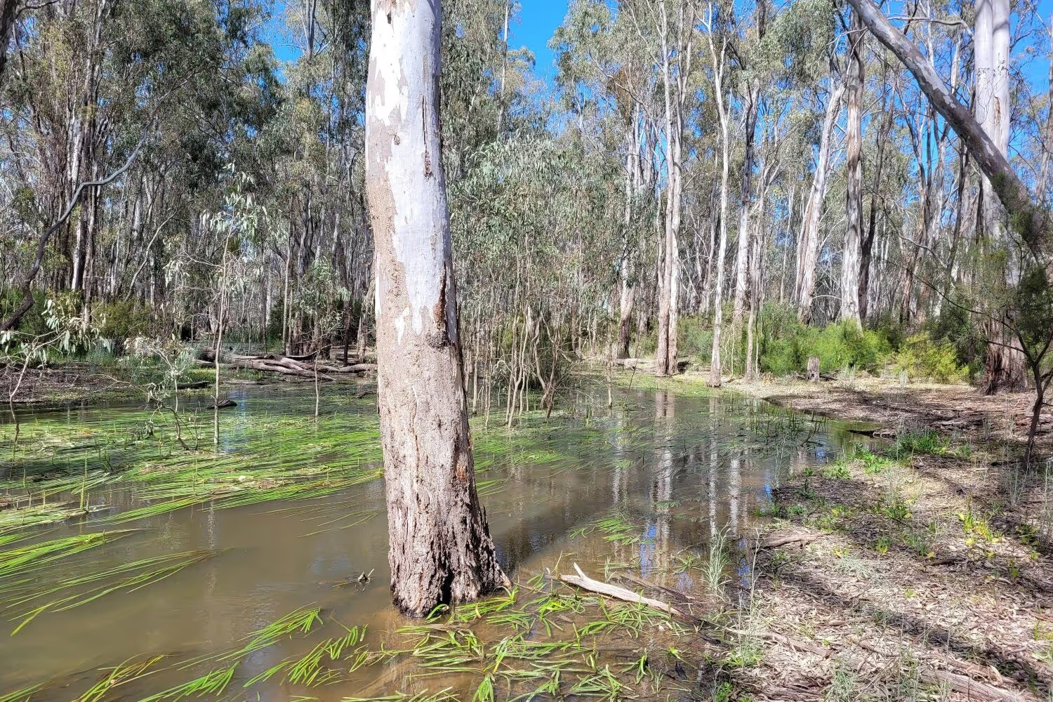
Water is the lifeblood of the Murray-Darling Basin, it courses through rivers and streams from the headwaters in southern Queensland and the eastern highlands, to the estuary and river mouth in South Australia. Along the way rivers and streams replenish a rich array of lakes, wetlands and floodplain ecosystems.
Over the past 10 years, the Ecosystem Diversity Theme has worked to quantify the contribution of Commonwealth environmental water to protecting and restoring these water-dependent ecosystems in the Basin.
Image: Intersection of ecosystem and environmental water mapping along the Murray River upstream of Robinvale. Creator: Shane Brooks
Introduction
The Murray-Darling Basin is a rich tapestry of water-dependent ecosystems that includes rivers, streams, billabongs, lakes, wetlands, floodplains and an estuary. These water-dependent ecosystems provide vital habitats for a wide range of plant and animal species.
The Ecosystem Diversity Theme quantifies the water-dependent ecosystems that benefit from Commonwealth environmental water. The work undertaken has pioneered the bringing together of multiple datasets to further our understanding of the significance of water for the environment within the Basin.

The contents on this page includes summarised text from the Basin-scale evaluation of 2023-24 Commonwealth environmental water: Ecosystem Diversity report. Page number references have been noted throughout the content below for anyone using the full report.
5 key areas of impact have been identified:
Each year, the Commonwealth Environmental Water Holder (CEWH) delivers water to ecosystems that are broadly representative of the water-dependent ecosystems found throughout the Murray–Darling Basin and are vital for maintaining Basin biodiversity.
Our understanding of the ‘managed floodplain’ area within the Basin has deepened, as well as the CEWH’s ability to water it. For example, in 2023–24, Commonwealth environmental water supported 200,890 ha of lakes and wetlands, representing 75% of the lake and wetland diversity and 27% of the total area of lakes and wetlands on the managed floodplain.
Of the 16 Ramsar wetlands in the Basin, 11 are regularly supported by Commonwealth environmental water, often in collaboration with other environmental water holders. In 2023-24, 1,835 GL of Commonwealth environmental water was delivered to 8 Ramsar Sites in the Basin, supporting vegetation listed as a critical component of the Ramsar Sites.
CEWH water is critical in enabling Basin water-dependent ecosystems to be maintained in a variable climate. In alignment with Basin-wide environmental watering strategy (BEWS) annual priorities, the extent of watering by the CEWH varies with the climate, with more extensive use of water management to support floodplain and wetland ecosystems in wetter years to maximise ecological benefits, retracting to the focused protection of key aquatic ecosystems during droughts.
This theme has led to innovation in managing large quantities of data to understand patterns in space and time, which has seen the development of new ways to interpret and visualise large data sets in order to evaluate environmental watering of ecosystems at a landscape scale.
Helpful definitions
The Australian National Aquatic Ecosystem Classification (ANAE) is a systematic framework that categorises aquatic ecosystems in Australia, focusing on their ecological characteristics, functions, and values. It aids in biodiversity conservation, environmental water management, and policy development by providing a standardised approach to understanding aquatic habitats.
The managed floodplain is the estimated area of the Basin that can be influenced by environmental water management. It includes actively managed areas that can receive environmental water delivered from large headwater storages, or via ‘environmental works’ sites on the Murray River floodplain from The Living Murray Program. It also includes passively managed areas that receive environmental water via flow rules in water resource plans, or via natural events.
A ‘constraint’ as defined by the Murray–Darling Basin Authority, is anything that limits water from reaching floodplains, creeks, and wetlands. This includes physical barriers such as low-lying bridges and crossings, as well as operational factors such as river management rules or practices. These features of the river system developed over many years as industries and communities grew and rivers became more regulated. Constraints can reduce efficiency in the system, and hinder its ecological health, limiting the full environmental benefits of water recovered under the Basin Plan.
The Ramsar Convention on Wetlands of International Importance, signed in 1971 in the town of Ramsar, Iran, is the first modern international treaty focused on conserving natural resources, specifically wetlands. It aims to halt global wetland loss and promote their sustainable management through international cooperation, policy-making, capacity building, and technology transfer. Australia has obligations under the Ramsar convention to care for wetlands listed under the Ramsar Convention.
.webp)
Our approach
The Ecosystem Diversity evaluation explores the key question: What did Commonwealth environmental water contribute to ecosystem diversity?
To do this, our work documents the range of water-dependent ecosystems that potentially benefit from environmental water, including at Ramsar sites, to evaluate the contribution of Commonwealth environmental water to the following Basin Plan objectives:
8.05(3)(b): to ensure that representative populations and communities of native biota are protected and, if necessary, restored; and
8.05(2)(a): to protect and restore a subset of all water-dependent ecosystems of the Murray–Darling Basin, including by ensuring that declared Ramsar wetlands that depend on Basin water resources maintain their ecological character.
This evaluation does not directly measure the responses of water-dependent ecosystems. Instead, it provides data that supports other related Flow-MER Themes of Vegetation, Fish, Food Webs and Water Quality, and Species Diversity, which offer more detailed reports on the responses of species, populations, and ecosystem functions within the Basin’s aquatic ecosystems.
The evaluation also supports the Flow-MER project’s focus on specific species groups such as fish, waterbirds, frogs, and plants, found across water-dependent ecosystems of the Basin.
This evaluation relies on 4 datasets:
The Australian National Aquatic Ecosystem (ANAE) Classification of the Murray–Darling Basin v3.0, which maps and classifies over 300,000 aquatic ecosystems into 66 ecosystem types (Figure 1).

Inundation by Commonwealth environmental water, within each water year (e.g. 2023-24 shown in Figure 2) and cumulative since 2014 (not shown).
CEWH Basin valley boundaries as defined for the Flow-MER Program and previous Long-Term Intervention Monitoring Program (Figure 3).

The ‘managed floodplain’, or the area identified through the Basin-wide environmental watering strategy as being within scope for environmental watering (Figure 4).

The Ecosystem Diversity evaluation continues the sequence of annual and cumulative evaluation established during the Long Term Intervention Monitoring Project (LTIM from 2014–19). While the approach has not changed substantively from previous evaluations, the datasets and mapping have improved over time.
This has prompted a re-analysis of all previous hydrological inundation and ecosystem mapping data since monitoring began in 2014–15, so that we could incorporate these improvements and ensure results in the cumulative analysis are comparable among years.
What we’ve learned
Does water for the environment benefit aquatic ecosystems?
Work in the Ecosystem Diversity theme has clearly shown the critical importance of Commonwealth environmental water to supporting and maintaining representative water-dependent ecosystems across the Basin. The extent, scale and impact of watering is described below in 5 key areas.
Watering a representative subset of aquatic ecosystem types
(pages iv-v)
In the 2023-24 water year, the Commonwealth environmental water supported 52 ANAE ecosystem types (79% of the ecosystem types currently mapped in the Basin and 81% of the types found on the managed floodplain). In addition to this:
- Commonwealth licences were used to retain high flows in the Warrego River, which spilled westward into the Cuttaburra distributary and delivered Commonwealth environmental water to the nationally significant Cuttaburra and Yantabulla wetlands in the Paroo valley for the first time since monitoring began in 2014.
- End-of-system flows supported 23,768 ha of estuary habitat in the Coorong and Murray Mouth (100% of the estuary on the managed floodplain) and contributed to maintaining the ecological character of the Coorong, and Lakes Alexandrina and Albert Wetland Ramsar Site.
Over the 10-year period (2014-24), Commonwealth environmental water supported 56 aquatic ecosystem types representing:
- 39,568 ha of lakes, representing 18% of lake area on the managed floodplain upstream of the Lower Lakes, or 124,091 ha for the Basin
- 130,574 ha of 24 types of palustrine wetland
- 191,599 ha of 12 types of floodplain
- 28,549 km of 7 types of waterway
- 23,768 ha of 9 estuarine ecosystems
At the Basin scale, Commonwealth environmental water contributed to watering frequencies that were broadly consistent with expected requirements – with more frequent support of permanent rivers, lakes, meadows and permanent tall marsh, and less frequent inundation of temporary channels, swamps and floodplains.
Watering the ‘managed floodplain'
(pages iv)
In 2023-24, Commonwealth environmental water supported 200,890 ha of lakes and wetlands of 27 different types, representing 75% of the lake and wetland diversity and 27% of the total area of lakes and wetlands on the managed floodplain.
Commonwealth environmental water supported longitudinal connectivity through 21,075 km of rivers (40% of the river length on the managed floodplain). These were predominantly permanent and temporary lowland rivers (97% combined) that connected laterally with 47,770 ha of floodplain.
Watering Ramsar sites
(pages vi, 15, 24)
In 2023-24, approximately 1,835 GL of Commonwealth environmental water was delivered to 8 Ramsar Sites in the Basin, supporting vegetation listed as critical component of the Ramsar Sites. For example,
- 23,495 ha (100%) of river red gum swamp in the Barmah Forest Ramsar Site
- 8,895 ha of river red gum floodplain and another 658 ha of river red gum swamps in the NSW Central Murray State Forests Ramsar Site.
- Extensive inundation (2,676 ha, or 99%) of the tall marsh of the Macquarie Marshes Ramsar Site.
- Inundation of 2,660 ha of lignum in the Narran Lakes Ramsar Site.
Supporting the Basin Plan and BEWS by responding to annual needs and climate variability
Basin Plan (pages vi, 76)
The Basin Plan sets high-level objectives to ensure that the water-dependent ecosystems of the Murray–Darling Basin are resilient to climate change and other risks and threats (Basin Plan section 8.04).
Objectives for the Protection and restoration of water-dependent ecosystems are set in Section 8.05, and for the Protection and restoration of ecosystem functions of water-dependent ecosystems are set out in Section 8.06. The following results outline the multi-year contributions of environmental water deliveries to realising these objectives.
Basin Plan objective at paragraph 8.05(3)(b): to ensure that representative populations and communities of native biota are protected and, if necessary, restored.
- Ecosystems that are in scope for environmental water management are broadly representative of ecosystem types elsewhere in the Basin. Of the Basin ecosystem types, 97% occur on the managed floodplain, and the relative abundance (by area) of ecosystem types is similar when comparing the managed floodplain to the whole Basin.
- In 2023–24, there were 52 ANAE ecosystem types, representing 81% of the ecosystem diversity on the managed floodplains, that received Commonwealth environmental water. They cover a combined area of 272,428 ha. An additional 21,075km of river representing the ‘populations and communities of water-dependent native biota’ was assumed to have been supported or ‘protected’ by the environmental water they received. The evaluation is unable to examine if ecosystems were ‘restored’.
- The 10-year watering history (2014–24), included a similar diversity of ecosystem types through the years–56 ecosystem types (comprising an area of 470,031 ha and 23,767 km of rivers) were supported by Commonwealth environmental water. Ecosystems that are not being watered are the naturally wet bogs, springs and paperbark swamps and the saline systems where delivery of freshwater is likely not appropriate.
Basin Plan objective at paragraph 8.05(2)(a): to protect and restore a subset of all water-dependent ecosystems of the Murray–Darling Basin, including by ensuring that declared Ramsar wetlands that depend on Basin water resources maintain their ecological character.
- Commonwealth environmental water was delivered to 8 Ramsar Sites in 2023–24, supporting a total of 172,667 ha of 50 different ecosystem types within the Ramsar estate. This areal extent is dominated by the 79,418 ha of lakes Alexandrina and Albert and 18,845ha of the Coorong Lagoon. Excluding these 3 waterbodies in the Coorong, Lower Lakes and Murray Mouth, Commonwealth environmental water directly supported 74,404 ha of Ramsar ecosystems. Some evidence for supporting critical components, processes and services of Ramsar Sites were identified (e.g. protecting and/or maintaining frequency of inundation to support vegetation, which in turn supports breeding and foraging habitat for waterbirds). However, a detailed investigation to determine if Ramsar Site ecological character was maintained (the Basin Plan objective) was outside the scope of Flow-MER evaluation.
Basin-wide environmental watering strategy (BEWS) (pages v, 42, 80)
Commonwealth environmental watering is responsive to climatic conditions from year to year, and sufficiently agile to deliver water in accordance with the Basin-wide environmental watering strategy’s annual priorities. For example, natural flooding in 2016–17 meant watering of floodplains was not a priority, but after two wet years in 2021–22 and 2022–23, the floodwater receded quickly in summer 2024, and there was extensive use of Commonwealth environmental water to support breeding waterbird rookeries. In the driest year on record (2019–20) Commonwealth environmental water was directed in-channel to support base flows and top-up refuge pools.
In the 2023-24 water year, vegetated ecosystems were supported in agreement with the Strategy’s Basin-wide annual watering priorities:
- Non-woody vegetation priorities to provide opportunities for growth were met. Commonwealth environmental water was delivered to 30,835 ha of meadow and marsh upstream of the Lower Lakes and another 9,803 ha of marsh around the Lower Lakes. 12 ha of sedge/forb/grassland riparian zone or floodplain and 21,075 km of river channel were inundated, supporting non-woody riverbank vegetation.
- A rolling priority to maintain the extent, improve the condition, and promote recruitment of forests and woodlands was met. Commonwealth environmental water was delivered to 38,658ha of woody wetlands (swamps) and 47,684ha of woody floodplain vegetation.
- A rolling priority to maintain the extent and improve the condition of lignum shrublands and an annual priority to support continued recovery of lignum shrublands at Narran Lakes and other key sites in the northern Basin were met.4,895ha of lignum floodplain were inundated, and another 215ha of temporary lignum swamp received Commonwealth environmental water.
Advancing data analysis, evaluation methods and application
The Ecosystem Diversity Theme has evolved over time to become a highly valued and important dataset to understand types of ecosystems Commonwealth environmental water supports across the Murray-Darling Basin. Key steps in this evolution of data analysis and application include:
- Development of the ANAE classification (2011-12): The ANAE was created to identify high-value aquatic ecosystems based on diversity, uniqueness, habitat, naturalness, and representativeness.
- Basin ecosystem map (2012): CEWH, VEWH, states, and MDBA mapped water-dependent ecosystems to standardise ecosystem classification and support environmental water management.
- Murray-Darling Basin Plan (2012): Launched with objectives to protect and restore water-dependent ecosystems, requiring a consistent classification method.
- Identifying the managed floodplain (2018): Introduced to guide environmental water management on specific floodplain areas, allowing overlay of ANAE classification to assess ecosystem diversity and representativeness.
- Capacity for ecosystem management: This dataset provides insight into which ecosystems can be managed with environmental water, helping to meet Basin Plan objectives.
- Annual water mapping: Enables yearly tracking of where environmental water goes and which ecosystems are reached.
- Evaluating ecosystem diversity: Developed ecosystem richness scale, identifying rich areas such as the northern basin and Coorong.
- Ten years of water patterns: Tracks water distribution at ecosystem and larger scales, with extensive data collection.
- Adaptive management implications: Improved understanding of watering patterns, especially for wetlands near channels and core rivers in dry years.
- Support for floodplain ecosystems: Data shows Commonwealth environmental water supports:
- 88% of water-dependent ecosystem types on the managed floodplain.
- 39,568 ha of lakes, 130,573 ha of floodplains, 191,599 ha of waterways, 23,768 ha of estuarine ecosystems.
- Managed floodplain representativeness: The Ecosystem Diversity Theme has shown that Commonwealth environmental watering supports a diverse array of aquatic ecosystems on the managed floodplain that are representative of the diversity of aquatic ecosystems found throughout the Basin.
- Ecosystem condition assessment: Ten years of data enables ecosystem health assessment, showing trends in condition over time.
- Condition shifts in wet/dry periods: We can now use this living, breathing dataset to interrogate ecosystem condition shifts with climate and how environmental water plays a role in supporting these systems across these climatic shifts.
See the section entitled ‘Beating a path to ecosystem-scale evaluation’ that is a presentation Dr Shane Brooks gave on the above changes over time.
Informing adaptive management
(pages vii and 70)
The evaluation has not found any compelling evidence to recommend changes to the management of Commonwealth environmental water. Evaluation of Basin-scale watering frequencies shows that Commonwealth environmental water is being used to manage ecosystems that are representative of the managed floodplain and that, except for high-energy upland streams, are a representative subset of water-dependent ecosystems in the Basin. Watering frequencies broadly align with expected needs of vegetation groups–permanent lowland rivers, freshwater meadow and permanent tall marsh ecosystem types were watered more frequently than most swamps, and palustrine wetlands watered more frequently than floodplains. Saltmarshes, salt lakes and bogs were not watered.
The 10 years of inundation mapping have added another 10% by area to the managed floodplain–6,736 of mapped ANAE wetlands and floodplains covering 359,091 ha were added. This improves our knowledge of the extent and number of ecosystems that are potentially in scope for environmental water management in the Basin.
Creation of a unified register describing the purpose, timing, duration and extent of all environmental water management, along with observed outcomes and any unintended consequences, would empower improved Flow-MER evaluation and inform the collaborative planning process.
Development of watering objectives for ecosystem types and expected ecosystem-scale outcomes would support a performance-driven evaluation to assess the impact of Commonwealth environmental water beyond the current simplistic view that documents the pattern of water delivery with assumed benefits.

Informing the planning and management of water to protect and restore ecosystem diversity in the Basin
The 10 years of continued evaluation of ecosystem diversity supported by Commonwealth environmental water is clarifying:
the spatial pattern of watering actions in the landscape among valleys at the Basin scale.
the distribution of Commonwealth environmental water to the different ecosystem types to ensure ecosystems receiving water are representative of Basin ecosystems.
watering frequencies at ecosystem and wetland-complex scales.
The 114 watering actions in 2023–24 inundated substantial areas (>1,000 ha total) of floodplains and floodplain wetlands in 8 of the 25 valleys of the Basin. In the southern Basin, Commonwealth environmental water delivered to the Broken, Campaspe, Goulburn, Loddon, Ovens and Wimmera rivers in Victoria was confined to the river channels, benefiting a small number of in-channel weir pools and connected wetlands. In the northern Basin, a similar pattern was seen with in-channel flows in the Namoi, Barwon Darling and Border rivers.
Similar to the previous year, the largest areas of inundated wetlands and floodplain were from Commonwealth environmental water that was delivered to extend the duration of widespread natural flooding and provide cues to support waterbird breeding rookeries (Condamine Balonne, Lachlan, Gwydir, Macquarie and Murrumbidgee valleys) and fish movement and breeding (Central Murray and Murrumbidgee valleys). This is the first year since monitoring began that Commonwealth environmental water inundated areas in the Paroo valley. These flows originated in the Warrego River, where licence rules were triggered to retain high flows in the Warrego River that spilled westward into the adjoining Cuttaburra distributary and to the nationally significant Cuttaburra and Yantabulla wetlands in the Paroo valley.
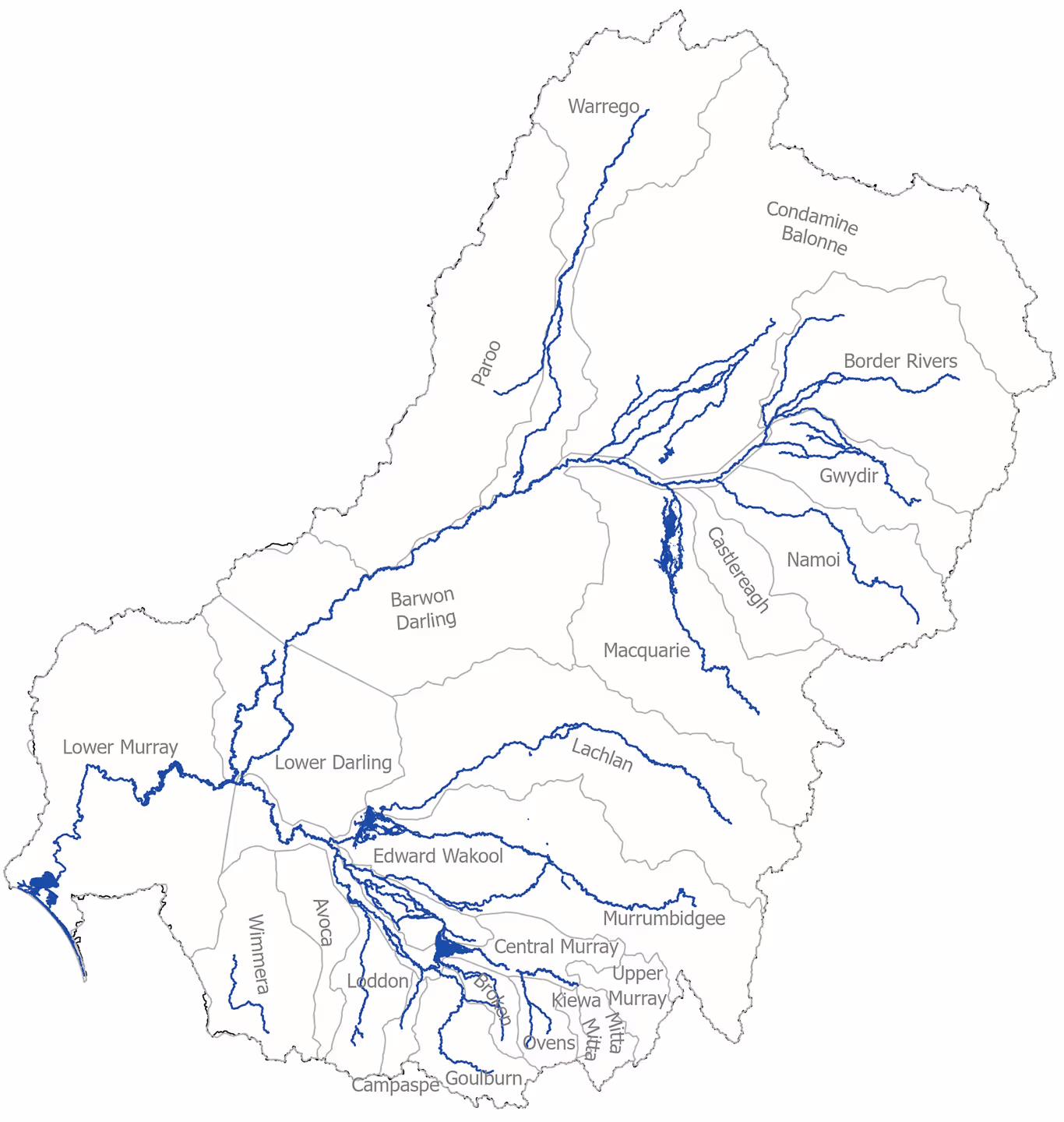
Volume of Commonwealth water for the environment delivered to Murray-Darling Basin regions
Commonwealth water for the environment is used to support a range of ecosystems across the Basin, including Ramsar wetlands. The map below shows the number of ecosystem types on the managed floodplain in each valley supported by Commonwealth environmental water in 2023-24, including the Ramsar sites which received Commonwealth environmental water.
Commonwealth environmental water delivered to:
Watering actions:
Number of ecosystem types on the managed floodplain in each valley supported by Commonwealth environmental water

Commonwealth environmental water supported 81% of ecosystem types including 75% of the lake and wetland diversity and 27% of the total area of lakes and wetlands on the managed floodplain.
Commonwealth environmental water delivered 1,835 GL to 8 Ramsar Sites in the Basin supporting nominated critical components, processes and services.
2,660 ha of lignum floodplain inundated to support the continued recover of lignum shrublands at Narran Lakes and other key sites in the northern Basin.
What is the Australian National Aquatic Ecosystem Classification (ANAE)?
Ecosystem types in the Basin are defined by the ANAE Classification Framework. The framework was designed to support adaptive management and monitoring of water-dependent ecosystems across the multiple jurisdictions in the Basin, by providing a common language for describing and naming aquatic ecosystem types. The ANAE classification of the Basin v3.0 provides the most complete contemporary mapping of the distribution and extent of water-dependent ecosystems in the Basin. The areas of approximately 300,000 aquatic ecosystems have been mapped to 5 high-level system classes. These are further classified into 66 ANAE types, including: 8 types of lake, 29 types of palustrine wetland, 12 floodplain types, 8 river types, 9 estuarine ecosystem types, and waterholes and springs. They represent a combined area of approximately 83,000 km2 or nearly 8% of the Basin. Ecosystem diversity is quantified as the number of different ANAE types and their areas that received Commonwealth environmental water.
Only the widest sections of larger rivers are mapped as areas. There are approximately 200,000 river features mapped, representing 50,000 km of perennial flowing rivers, and more than 400,000 km of temporary flowing rivers and streams. Because they are mapped as line segments, the ecosystems receiving Commonwealth environmental water are quantified by their river length (km), in contrast to the wetlands and floodplains that are quantified by area (hectares; ha).


Summary of ANAE types and contribution of Commonwealth environmental water on the managed floodplain
The map below shows the ecosystem diversity (number of ANAE types on the managed floodplain) supported* by Commonwealth environmental water in 2023-24. *For this evaluation, river and floodplain ecosystem types are deemed supported by Commonwealth environmental water in the areas that are inundated. The inundated area is the floodplain area that is overlapped by the mapped extent of inundation.

Numbers in each valley are the number of ANAE types inundated or influenced by CEW on the managed floodplain in each valley (see Appendix A in the full report for lists of ecosystem types within valleys). Depth of shading indicates lowest (lightest) to highest (darkest) ecosystem diversity.
Outcomes for Basin water-dependent ecosystems
Lake ecosystems
(pages 42-43)
Commonwealth environmental water was consistently delivered to 2 of the 8 lake types found in the Basin, but together they make up 92% of the lakes by area in the Basin and on the managed floodplain. Commonwealth environmental water was delivered more frequently for the maintenance of permanent lakes, except in 2020–21 and 2022–23, where water was delivered to the large temporary Lake Brewster (6,500 ha) in the Lachlan Valley to support pelican breeding and waterbird foraging. This pattern is consistent with the hydrological needs of these systems, as temporary lakes also require dry periods to maintain ecosystem processes.
The large increase in permanent lake inundation in 2017–18 (Figure below) was due to weir pool raising at Lock 8 and Lock 9 on the Murray River to push Commonwealth environmental water into Lake Victoria (a 10,738 ha permanent lake), to temporarily hold some water in a wet year for delivery at a later time (page 41).

Wetland ecosystems (palustrine)
(pages 44-46)
Definition:
Palustrine wetlands are shallow wetlands with a predominance of emergent vegetation (reeds, sedges, shrubs or trees).
There are 29 ANAE palustrine wetland types in the Basin, with 15 of the most common representing 99% of the total Basin wetland area. The managed floodplain contains 39% of Basin wetland area, comprised of the same 15 common types in similar proportions to the whole of the Basin. The palustrine wetlands on the managed floodplain, in scope for Commonwealth environmental water, are therefore qualitatively representative of palustrine wetlands in the Basin.
In the 10 years 2014–24, CEW supported 130,574 ha of 24 of the 29 ANAE palustrine wetland types in the Basin. Between 32, 666 ha (2014–15) and 79,955 ha (2022–23) were watered in any one year (average 65,090 ha). Ten wetland types (4,138 ha combined) received CEW every year.
- Temporary sedge/grass/forb marsh is the most extensive ecosystem type on the managed floodplain, covering 130,904 ha
- Temporary river red gum swamp was the wetland type with the largest area supported by CEW over the10 years (38,717ha)
- Eight wetland types did not receive any CEW. These are rare in the basin, occupy only 497 ha of the managed floodplain, and are types that are not targets for water management. They include ecosystem types for which freshwater additions could be detrimental


Floodplain ecosystems
(pages 47-47)
Approximately 28% of floodplains in the Basin align with the managed floodplain, and all 12 Basin floodplain ANAE types are represented there. The most common floodplain ecosystem types in the Basin (coolibah woodland and black box woodland floodplains) occur higher on the floodplain away from rivers, with only 24% of coolibah woodland floodplain and 17% of black box woodland floodplain located on the managed floodplain. In contrast, river red gum has a higher water requirement and is found lower on the valley floors closer to rivers, leading to a higher proportion of Basin river red gum (49%) being located on the managed floodplain. Despite these differences, the floodplain types located on the managed floodplain are representative of Basin floodplains.
Limited water volumes and policies to avoid inundating built assets or agricultural land often constrain Commonwealth environmental water to in-channel flows and watering of floodplain wetlands through regulators, and connecting channels rather than by overbank flooding. On average, only 3% of the managed floodplain received Commonwealth environmental water in any one year. In 2021–2022 and 2022–23, Commonwealth environmental water was delivered to the Macquarie Marshes, Gwydir Wetlands, Narran Lakes and Lowbidgee to support the maintenance of water at waterbird breeding rookeries that formed in response to extensive natural flooding. As a result, the extent of floodplain supported by Commonwealth environmental actions in the most recent 2 years (2021–23) was higher than in any previous year (average 72,947 ha, 5% of the managed floodplain). Over the 10-year period of monitoring, 191,526 ha of floodplains (191,599 ha including the CLLMM), comprising 12% of the managed floodplain, was inundated by Commonwealth environmental water at least once.
River red gum forest riparian zone/floodplain was inundated by Commonwealth environmental water to the greatest extent, with 77,257 ha inundated over the 10 years at varying frequencies, representing 22% of this ecosystem type on the managed floodplain.
The pattern of watering across years, seen in the Figure below, reveals some contrasts. The 2 years with the least floodplain inundation were 2016–17 and 2019–20: 2016–17 was a very wet year where watering of floodplains by Commonwealth environmental water was not seen as a priority; 2019–20 was the driest year on record and available Commonwealth environmental water was directed to supporting base flows, with only 2 of 155 planned watering actions targeting overbank flows. The 2021–23 period was also very wet, but unlike 2016–17, there was extensive use of Commonwealth environmental water to support completion of waterbird breeding in late summer, after winter rains reduced.


River ecosystems
(pages 49-52)
The managed floodplain contains 11% of the total river length in the Basin. This includes 76% of the total length of permanent lowland rivers in the Basin, and 24% of the temporary lowland river length. On the managed floodplain, lowland rivers dominate representing 86% of the 53,542 km total river length that is estimated to be in scope for water management (47% temporary lowland rivers and 39% permanent lowland rivers). With such a high proportion of these river types present on the managed floodplain, it is likely these ecosystems are representative of the other lowland rivers in the Basins. The 6 transitional and upland stream ecosystem types on the managed floodplain (7,485 km, 14%) are generally high-energy outflow channels from storages, before they flow out into the flat lowlands of the central and western Basin.
Commonwealth environmental water primarily supports permanent and temporary lowland rivers, with 97% of flow delivery in any one year being in lowland reaches. At the Basin scale in 2014–23, the annual allocation to river flows was very consistent, with 14,102 km up to 22,211 km of waterways potentially benefiting from Commonwealth environmental water annually (Figure below).
Over the 10-year period, 28,549 km of river was supported by CEW (54% of all the river length on the managed floodplain, Figure 5.13). Thirty-three per cent (9,419km) was watered in every year of the last 10 along permanent lowland sections of the Barwon, Macquarie, Gwydir, Lachlan, Murrumbidgee, Edward/Kolety–Wakool, Murray, Ovens, Broken, Goulburn and Loddon rivers. Permanent reaches in the lowland sections of the Bokhara, Culgoa, Darling and Campaspe rivers, and the smaller upland, transitional Severn River, received CEW in 9 of the10 years. Some temporary rivers have also received water in 7–8 of the years: Gunbower Creek, Tuppal Creek, the Moonie River, and the lower end of the Warrego River.


Extent of managed floodplain
The managed floodplain was initially mapped by MDBA in 2018. Approximately 32% of the Basin’s total area of lakes occurs on, or adjacent to, the managed floodplain, as well as 37% of total Basin palustrine wetland area, 25% of floodplains and 10% of river lengths (page 11). The Long Term Intervention Monitoring Project (LTIM) and the Flow-MER program have mapped inundation by Commonwealth water annually since 2014 using satellite imagery and observations by water managers.
These maps provide 10 years of additional evidence to support an update to the managed floodplain extent, as, by definition, all areas watered using Commonwealth environmental water are ‘managed’. The 10 years of monitoring has enabled us to add 373,844 ha to the managed floodplain, a 10% increase over the 2014 mapping. Of this area, 14,753 ha was added from new areas watered in 2023–24.
The extended managed floodplain intersects a further 8,001 mapped ANAE wetlands and floodplains, increasing our knowledge of ecosystems ‘in scope’ for environmental water management in the Basin. All figures and tables that refer to the managed floodplain in this report are using the updated managed floodplain extent.

Outcomes for Ramsar Sites
There are 16 Ramsar wetlands in the Basin, of which 12 are regularly supported by allocations of water from the Commonwealth, the Murray–Darling Basin Authority (MDBA) (e.g. The Living Murray Program), and state jurisdictions.
Commonwealth environmental water was allocated to 11 sites over the period of monitoring 2014–24. The Kerang Wetlands Ramsar Site is managed solely by Victoria, and 4 Ramsar Sites in the Basin currently cannot receive managed environmental water. Currawinya Lakes and the Paroo River Wetlands are in unregulated northern Basin locations, and Ginini Flats Wetland Complex is in the alpine region above any water storages.
The fourth site, Lake Albacutya, is the second of 2 large terminal lakes at the end of the Wimmera River – there is currently an insufficient volume of water in the system to first fill Lake Hindmarsh so that water can spill to Lake Albacutya.
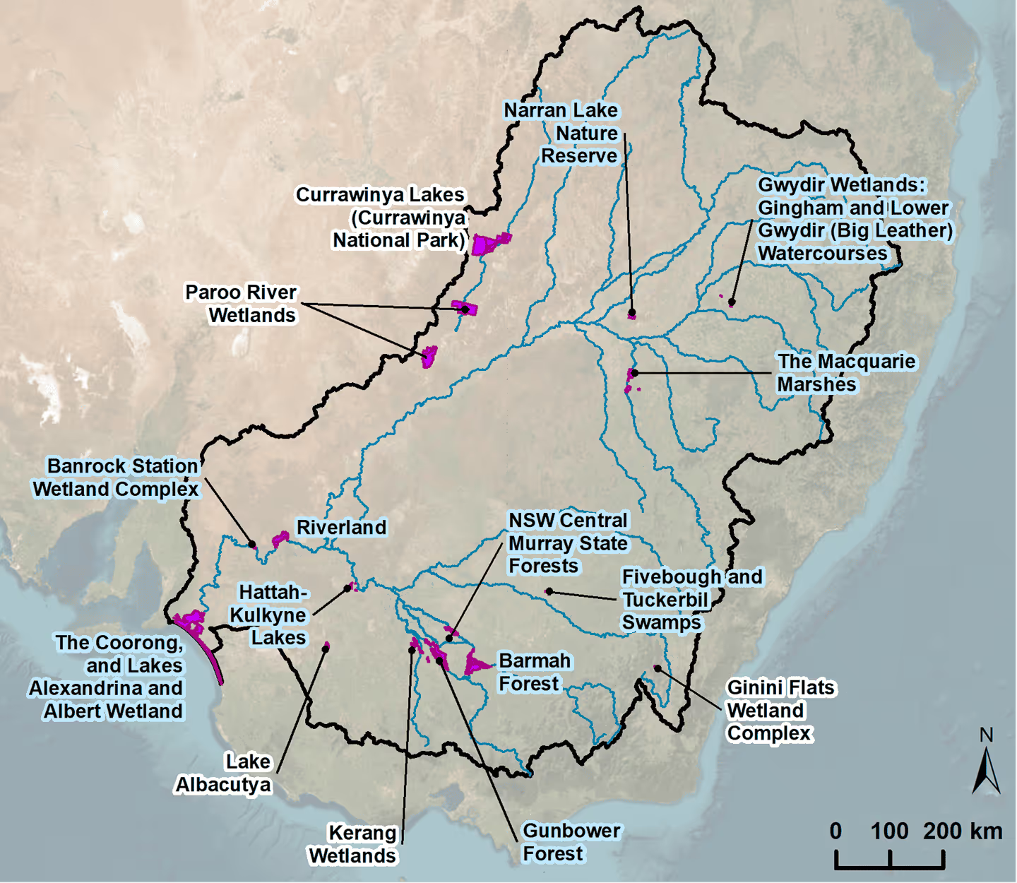
In 2023–24, approximately 1,984 GL of environmental water, containing 1,835 GL of CEW, was delivered to 8 Ramsar Sites in the Basin. In many instances, environmental water delivered to floodplains is returned to the river and used again to inundate sites downstream. For example, water in the Barmah Forest Ramsar Site flows back into the Murray River and then can be used to inundate Gunbower Forest, Hattah–Kulkyne Lakes and Riverland Ramsar Sites further downstream. Environmental water that reaches the Coorong, and Lakes Alexandrina and Albert Wetland Ramsar Site mainly comprises return flows from upstream watering.
The evaluation of ecosystem diversity supported by Commonwealth environmental water in Ramsar Sites differs from the Basin-scale method, using the ANAE polygon mapping for riverine ecosystems instead of the Basin-scale river line mapping. The ANAE polygon mapping is not used at the Basin scale because it does not include all rivers in the Basin. It is, however, complete within the limited extent of the Ramsar estate, allowing all ecosystem types within the Ramsar Sites to be compared by the mapped area, and the area that received Commonwealth environmental water.
The Ramsar site river polygons are assessed using the same logic applied to lakes, where the entire area of river polygons within Ramsar Sites are deemed supported by Commonwealth environmental water when overlapped in whole or in part by the satellite-derived inundation extent. At most Ramsar Sites, the water is delivered to the site via the river channel and occupies the whole channel.
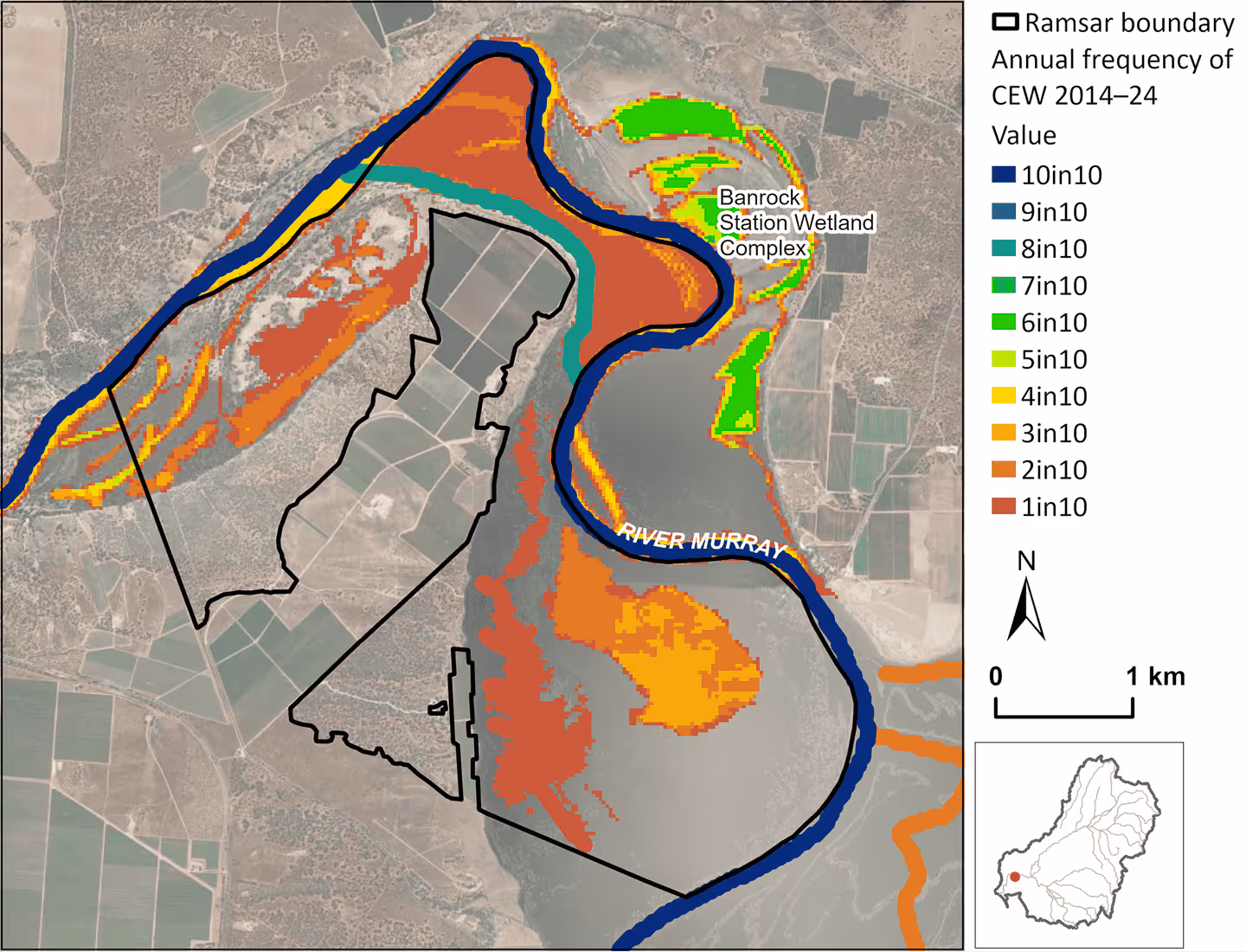
Banrock Station Wetland Complex
(pages 60-61)
At the time of listing in 2002, Banrock Lagoon was managed as a permanent wetland, but it is now managed for a wetting and drying cycle each year – wetting during spring, primarily to sustain dominant vegetation associations, with a drawdown over summer and autumn. Commonwealth environmental water was delivered to support the hydrological character of the Banrock Station Wetland Complex Ramsar Site in 7 of the 10 years 2014–24 to maintain this cycle. In 2022–23 the water needs of the site were met by natural flooding. The frequently inundated patches on the eastern bank of the Murray River are patches of lignum floodplain outside the Ramsar Site boundary. Areas of permanent wetland are watered in the central basin to support threatened southern bell frog (Litoria raniformis). A regulator installed in Wiggley Reach in 2020 allows Commonwealth environmental water to be delivered to black box floodplain that supports the threatened regent parrot (Polytelis anthopeplus).

Barmah Forest
(pages 62-63)
Barmah Forest Ramsar Site received Commonwealth environmental water in 8 of the 10 years 2014–24. During the 2 years that Commonwealth environmental water was not delivered, there were 2 natural floods in 2014–15, and ‘other’ environmental water (state and MDBA’s Living Murray Program) was used to inundate the site in 2016–17. The annual flooding is thought to mimic the natural regime for the site, as high winter–spring flows are constricted by the narrow channel of the Barmah choke, causing river water to back up and divert through channels in the floodplain. It is estimated that under pre-regulation scenarios, the site would have naturally flooded in 19 of the past 20 years. The extensive inundation in 2021–22 is the result of a large environmental water allocation of 414 GL (including 220 GL of Commonwealth environmental water) that was delivered to the site when it was already 45% inundated by naturally occurring high flows.
The Ecological character description (ECD) for the Barmah Forest Ramsar Site notes that, at the time of listing, the hydrological regime may have been insufficient to maintain the character of the site in the long term, emphasising that regular managed inundation by environmental water in dry periods is critical to maintaining and restoring the site.


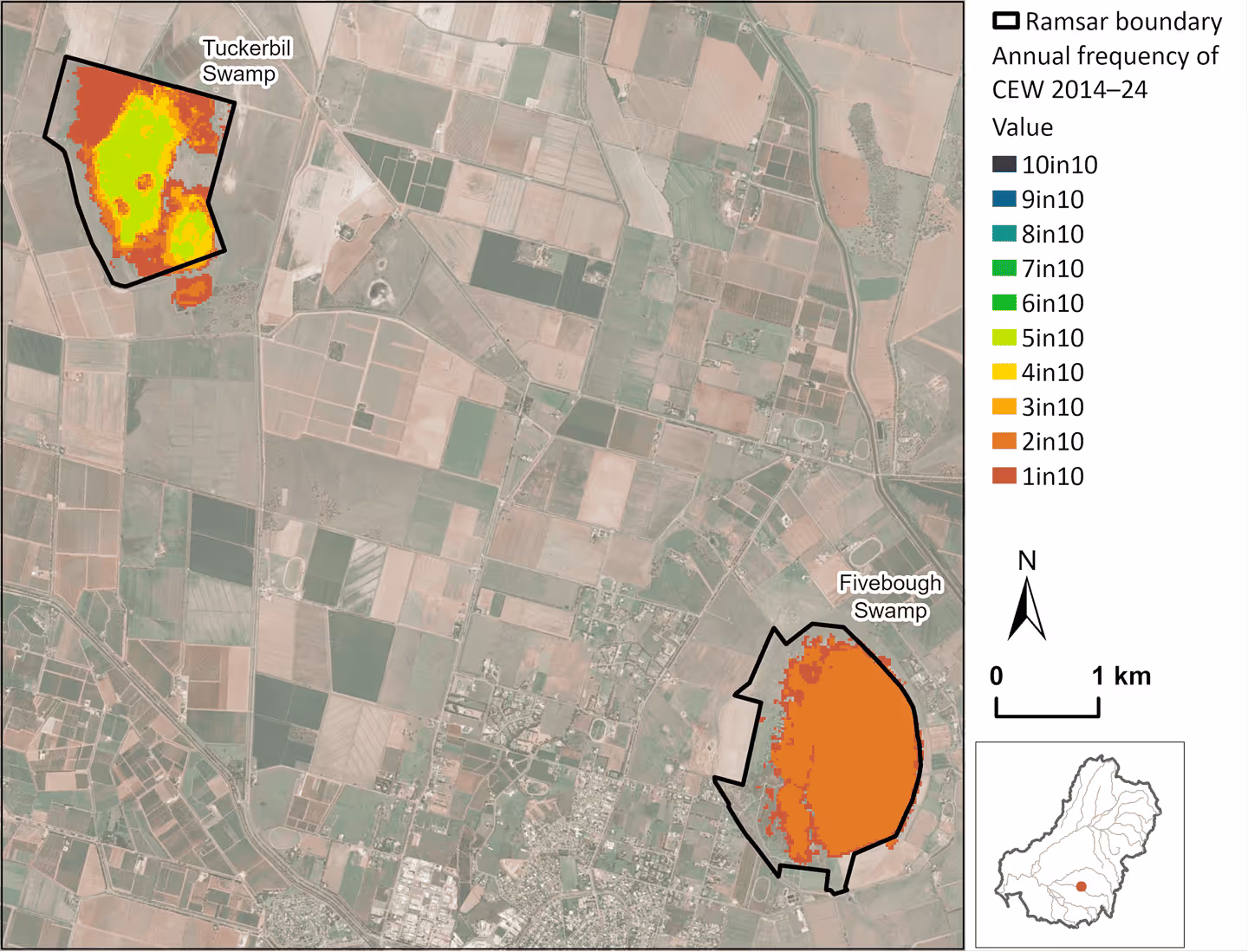
Fivebough and Tuckerbil Swamps
(pages 64-65)
Fivebough and Tuckerbil Swamps Ramsar Site received Commonwealth environmental water in 4 of the 9 years 2014–23. Fivebough Swamp is a permanent shallow wetland that was ‘topped up’ after 2 dry years in 2018–19 and 2020–21 using Commonwealth environmental water, to support its value as a significant waterbird drought refuge and waterbird feeding and breeding site. Tuckerbil Swamp is a brackish, seasonal shallow wetland maintained by Commonwealth environmental water more frequently (4 of the last 9 years) to support migratory waterbirds and threatened waterbird species, including brolga (Grus rubicunda), Australasian bittern (Botaurus poiciloptilus) and Australian painted snipe (Rostratula australis). The swamps were inundated by natural flooding in 2022–23.

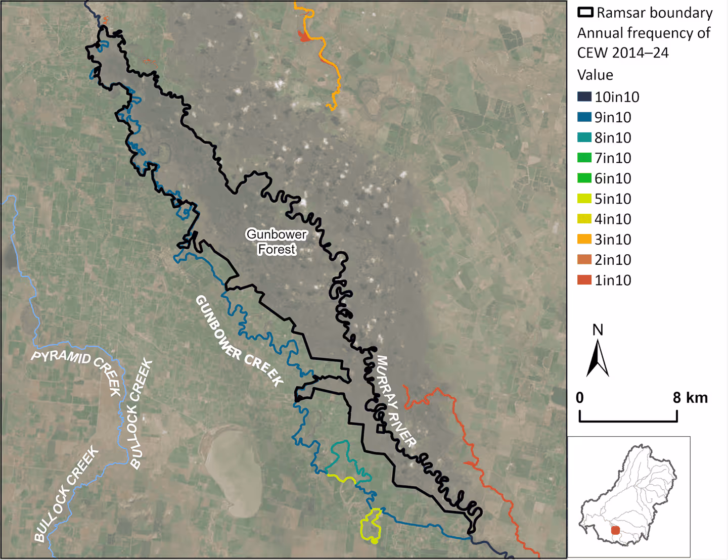
Gunbower Forest
(pages 66-67)
Commonwealth environmental water has been used in Gunbower Creek annually since 2015–16 to maintain native fish habitat and breeding. Gunbower Creek flows into the northern end of the Ramsar Site and regulators permit watering of adjacent wetlands. The Ramsar critical CPS include the ongoing presence of Murray cod (Maccullochella peelii peelii) and silver perch (Bidyanus bidyanus) in Gunbower Creek, and small-bodied fish in wetlands within the Ramsar Site, including Australian smelt (Retropinna semoni), carp gudgeons (Hypseleotris spp.), dwarf flat-headed gudgeon (Philypnodon macrostomus), flat-headed gudgeon (Philypnodon grandiceps), fly-specked hardyhead (Craterocephalus stercusmuscarum), and Murray-Darling rainbowfish (Melanotaenia fluviatilis). The Ramsar critical CPS for Gunbower Forest also include waterbird breeding and maintaining the extent and condition of river red gum floodplain, but these have not been objectives for Commonwealth environmental water during the monitoring period 2014–24. Wetland inundation by environmental water has not been mapped at this site, but occurred in 2021–22 within some smaller wetlands connected to Gunbower Creek in the northern end of the site.

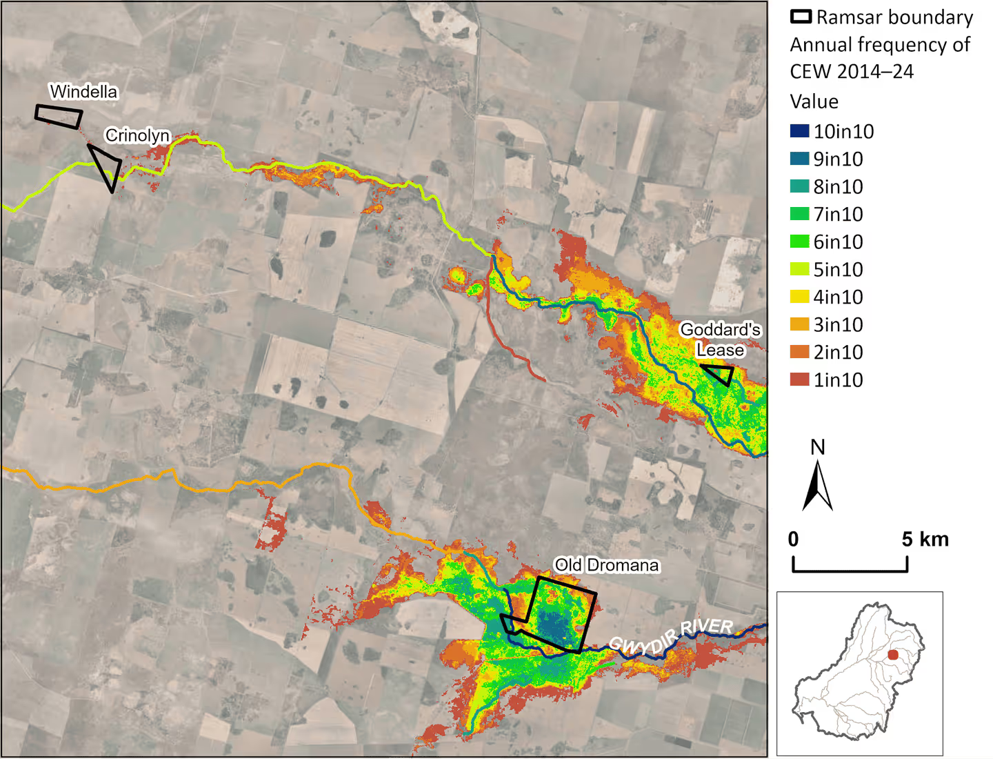
Gwydir Wetlands: Gingham and Lower Gwydir (Big Leather) Watercourses
(pages 68-69)
The Gwydir Wetlands: Gingham and Lower Gwydir (Big Leather) Watercourses Ramsar Site received Commonwealth environmental water in 9of the 10 years 2014–24. The exception in 2019–20 was when flows were constrained to the channel to protect river assets after 3 successive years of dry conditions. In early 2020, there was above average rainfall that provided a natural water source to revive the cooch grass meadows, and high flows have been maintained keeping the wetlands inundated from May 2021 – March 2023. In these wet years, Commonwealth environmental water was used to extend the duration of inundation over summer to keep water in waterbird nesting and foraging habitats until summer breeding was completed. The Ramsar Site consists of 4 isolated sub-units with Commonwealth environmental water primarily supporting Goddard’s Lease and Old Dromana, to support freshwater meadows dominated by water cooch and areas of tall marsh. The Gwydir River System Selected Area reports in detail on the outcomes from Commonwealth environmental water management at this site. This site does not have an ECD that defines the critical CPS.

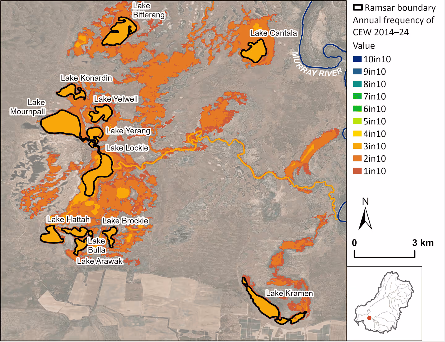
Hattah-Kulkyne Lakes
(pages 68-69)
In recent times, Hattah Lakes would connect to the Murray River via Chalka Creek when flows in the Murray River at Euston exceeded 36,700 ML/day. The ecological character of the site is now highly dependent on managed environmental water. Construction of a permanent pump station, regulators and environmental levees were completed as part of The Living Murray Program in 2014–15, when LTIM monitoring began. The pump infrastructure was used to deliver Commonwealth environmental water in 4 of the 10 years 2014–24. Watering ceased in 2019–20, to begin a planned ‘dry phase’. In the intervening years of 2016–17 and 2018–19, the floodplain was watered with contributions from The Living Murray. Mapping of other sources of environmental water in LTIM was not considered reliable or sufficiently comprehensive, and was discontinued in Flow-MER. Expanding the scope of this evaluation to include all water is recommended to provide a more accurate characterisation of the hydrological regime and, therefore, the contribution of Commonwealth environmental water as part of that regime. The lakes were partially filled in 2021 by Victorian environmental water aligned to high natural flows in the Murray River, and they drained back to the Murray over the summer. During winter and spring 2022, Victorian environmental water was delivered to the lakes, which were then flooded naturally by a flood event that was the largest since 1956 and estimated to have inundated 16,842 ha, compared to the 6,000 ha that can be inundated with environmental water alone.


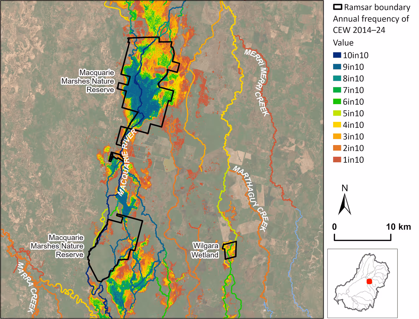
Macquarie Marshes
(pages 58-59)
Commonwealth environmental water contributed (along with jurisdictional water) to inundation of the Macquarie Marshes Ramsar Site, in 9 of the 10 years 2014–24. No inundation is shown for 2019–20. However, in this period approximately 4 GL of Commonwealth environmental water was accessed through supplementary licences on the Macquarie River, allowing some in-channel flows to replenish refuge pools and flow through to the marshes. Extensive inundation in 2022–23 was the result of watering actions following natural flooding events, to maintain waterbird breeding rookeries and provide waterbird foraging habitat.
Water management in the Macquarie Marshes is typically planned and executed for the larger extent of the marshes, and not just the 3 units that make up the Ramsar Site. Much of the southern marsh that is regularly inundated by Commonwealth environmental water is outside of the Ramsar Site boundary.
The Ramsar critical CPS for the site include indicators that are the focus of much of the jurisdictional monitoring, including the extent of tall marsh, lignum and river red gum, waterbird counts, and breeding of aggregate- nesting waterbirds.

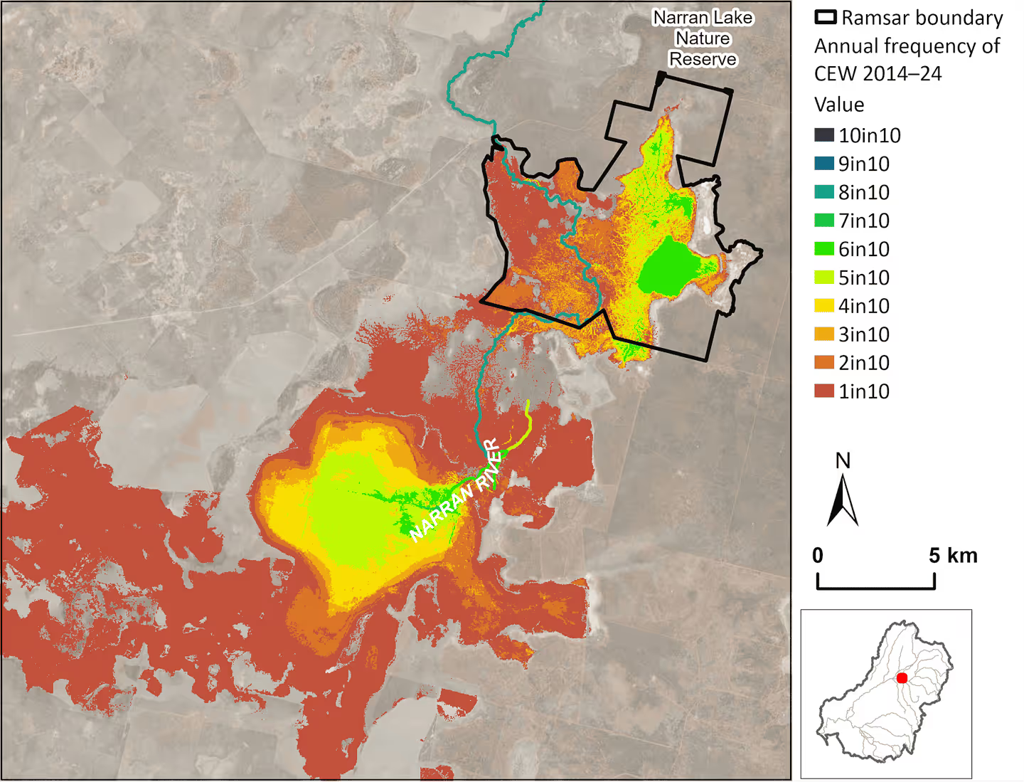
Narran Lakes Nature Reserve (Narran Lakes)
(pages 56-57)
The Narran Lake Nature Reserve Ramsar Site received Commonwealth environmental water in 6 of the 10 years 2014–24. Substantial inundation of lignum floodplain in 2019–20 has been followed up with water allocations in 2020–23 to improve lignum health and build resilience in the system, to support waterbird breeding and recruitment. Significant natural flows in the 2021–22 and 2022–23 years have maintained inundation at the site. Supporting regular breeding of aggregate-nesting waterbirds (in no less than 1 in 10 years) is listed as a critical service that characterises this site. Waterbird breeding commenced at the site after natural flooding in 2021–22, and again in 2022-24. Commonwealth environmental water was used to maintain water at rookeries through to the end of summer to provide breeding habitat and foraging areas for juveniles.

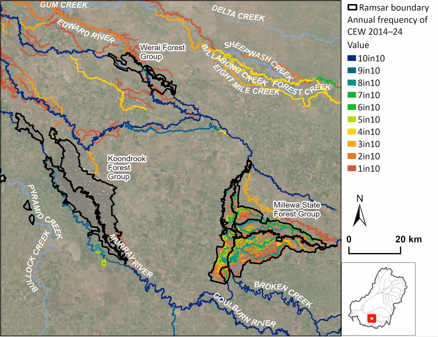
NSW Central Murray Forests (Koondrook and Werai forests)
(pages 70-71)
The NSW Central Murray Forests Ramsar Site received Commonwealth environmental water in 8 of the 10 years 2014–24. The site consists of 3 large river red gum forest groups: Millewa, Koondrook–Perricoota and Werai. The majority of environmental water is delivered via the Murray River, typically inundating approximately 4,000 ha or more of the Millewa section in conjunction with the Barmah Forest Ramsar Site on the opposite bank of the Murray River. In 2016–17, the Barmah and Millewa sites were watered with 155 GL from The Living Murray Program to provide the annual inundation cycle for both the Barmah and Millewa forests combined.
Wholesale inundation of the Millewa group is likely to contribute to the maintenance of the ecological character of the site. The ECD for the site defines ecological character at large spatial scales, based on the current measured extent of marshes and river red gum forest in each of the forest blocks. For example, there should always be more than 20,000 ha of river red gum forest in the Millewa group, and loss of forest extent would represent a change in character. Hydrological requirements defining the character of the site are defined using recurrence intervals of floods in the Murray River. For example, maintaining channels and low-lying areas in the Millewa group requires a minimum of 5 high flows of more than 12,500 ML/day for 70-day durations downstream of Yarrawonga in any 10-year period, which has been achieved to 2024.
Outside of the Barmah–Millewa, Commonwealth environmental water was only used at Pollock Swamp in the Koondrook group, a 700 ha nature reserve at the western end of the Ramsar Site (approximately 1% of the Ramsar Site area). A new program commenced annual pumping from the Murray in 2018–19, with 2–3.5 GL of Commonwealth environmental water released to restore approximately 100 ha of shallow wallaby grass and river red gum swamp. This project is likely to have successful outcomes, but, at this local scale, is a small contribution towards maintaining the ecological character of the Ramsar Site where critical CPS are defined at much larger scales. The remainder of the extensive Koondrook Forest Group (34,524 ha) and the Werai Forest Group (11,421 ha) have not received Commonwealth environmental water since monitoring began in 2014.
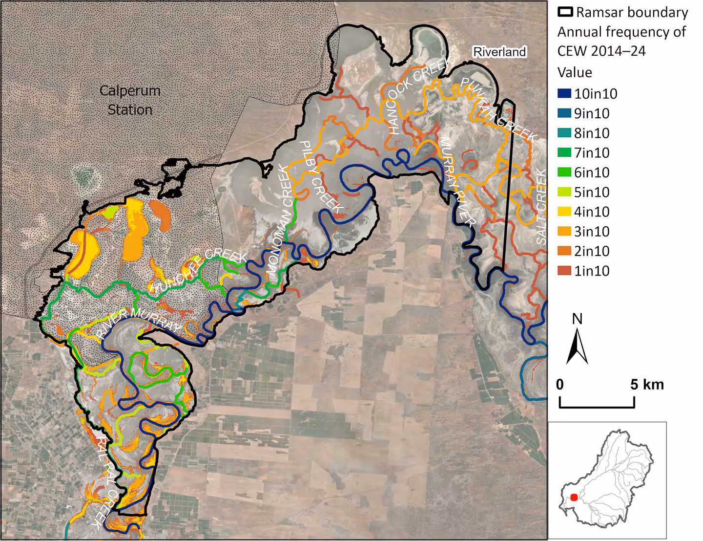
Riverland
(pages 72-73)
The Riverland Ramsar Site received Commonwealth environmental water in all 10 years 2014–24, inundating the site to varying degrees. The site is a large floodplain of the Murray River that includes the Chowilla and Calperum wetlands, and has many interconnecting channels and anabranches. Water is managed strategically through regulators and pumping to protect waterbird habitat and water-dependent vegetation, including stands of black box higher on the floodplain. The ECD defines hydrological character by the water requirements of different wetland types, which align to the Basin ANAE mapping, to use in evaluating the contribution of environmental water to maintenance of the Ramsar Site ecological character. For example, the bar chart below shows that Commonwealth environmental water is supporting a high diversity of ecosystem types at the site and appears to be used to protect the more permanent habitats, with larger areas of inundation of permanent wetland, permanent lake, permanent saline wetland and the permanent lowland river (the Murray River).

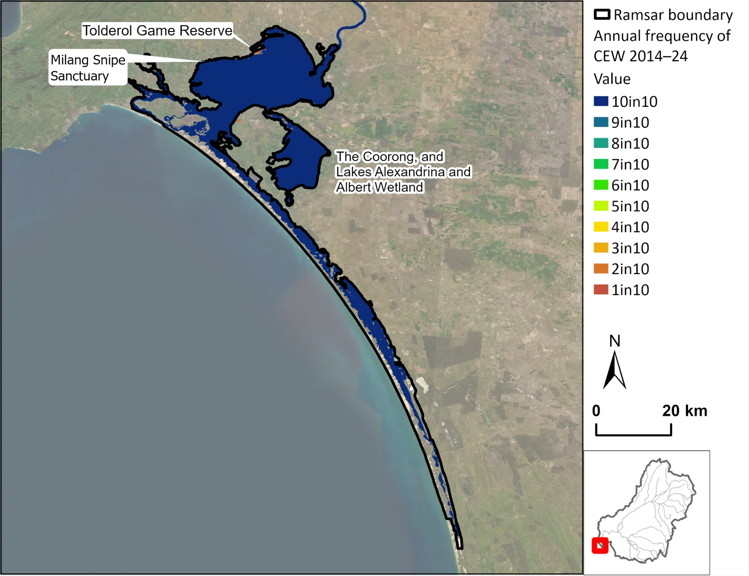
The Coorong, and Lakes Alexandrina and Albert Wetland
(pages 74-75)
The Coorong, and Lakes Alexandrina and Albert Wetland Ramsar Site received Commonwealth environmental water in all 10 years, either as allocations or end-of-system flows. Some attempts were made during LTIM to model changes in the large lake area in response to the relatively small quantities of environmental water received. However, the models were not sensitive enough to detect changes in inundation of wetland habitat that fringes the lakes. Flow-MER therefore uses the same inundated extent to represent the CLLMM in every year, and the composition of CLLMM ecosystem types supported by Commonwealth environmental water is mostly static, except for some small fringing areas that receive targeted allocations of water. For example, there was environmental watering of the Tolderol Game Reserve 2019–20 and 2020–21, and the Milang Snipe Sanctuary 2016–17 to 2021–22, to support migratory waders.