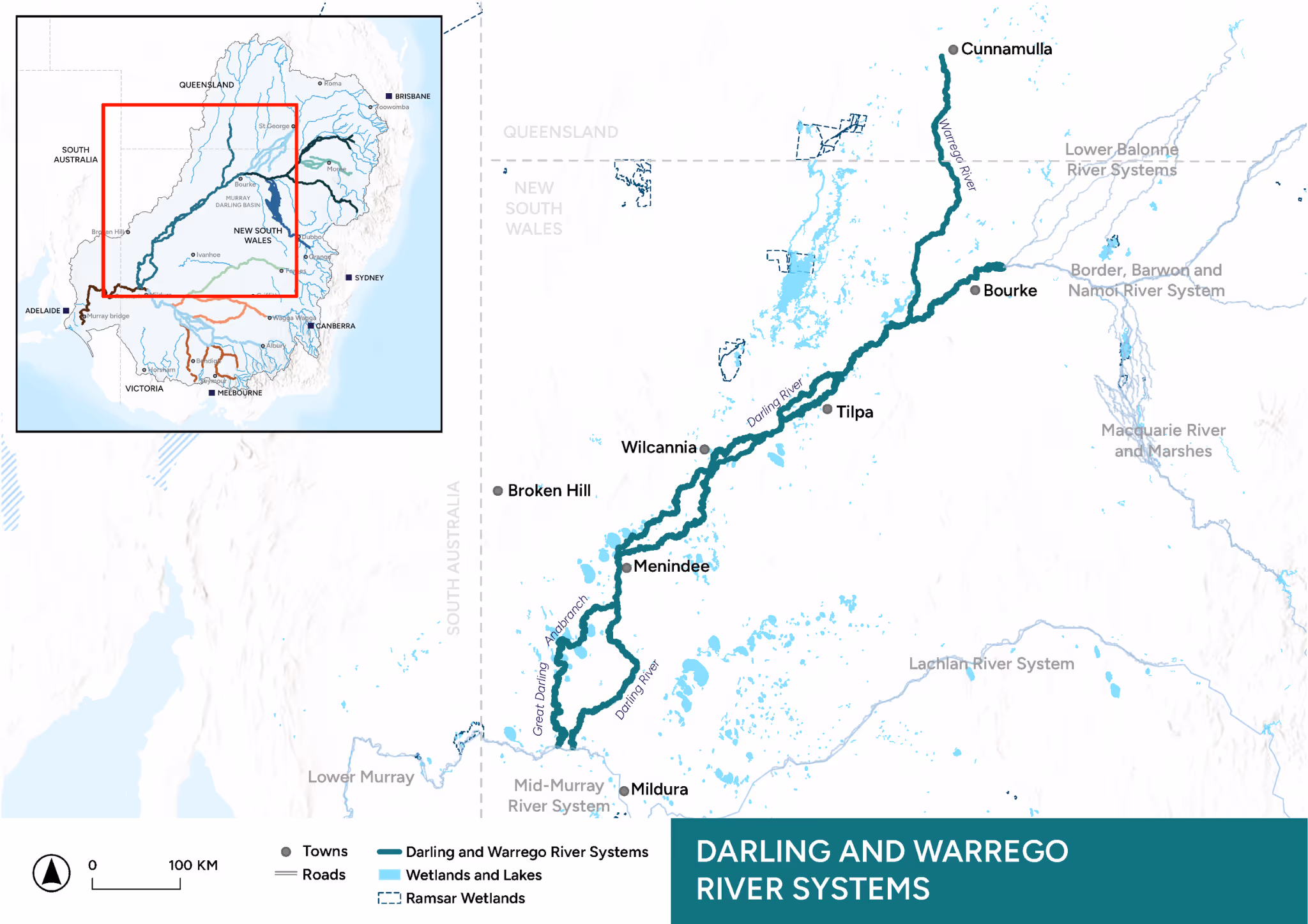
Darling and Warrego River Systems
Image: Pelicans, Western Floodplain, Toorale National Park (Nov. 2024). Credit: Dr Munique Reid, UNE.
About the Area
The Darling (Baaka) and Warrego (Warriku) River Systems stretch over 1300 km and contains rivers, wetlands, floodplains and lakes on the traditional lands of the Kurnu-Baakandji Peoples.
The systems extend from Cunnamulla in Queensland on the Warrego (Warriku) River to where it joins the Darling (Baaka) and Murray Rivers at Wentworth on the NSW Victoria border.
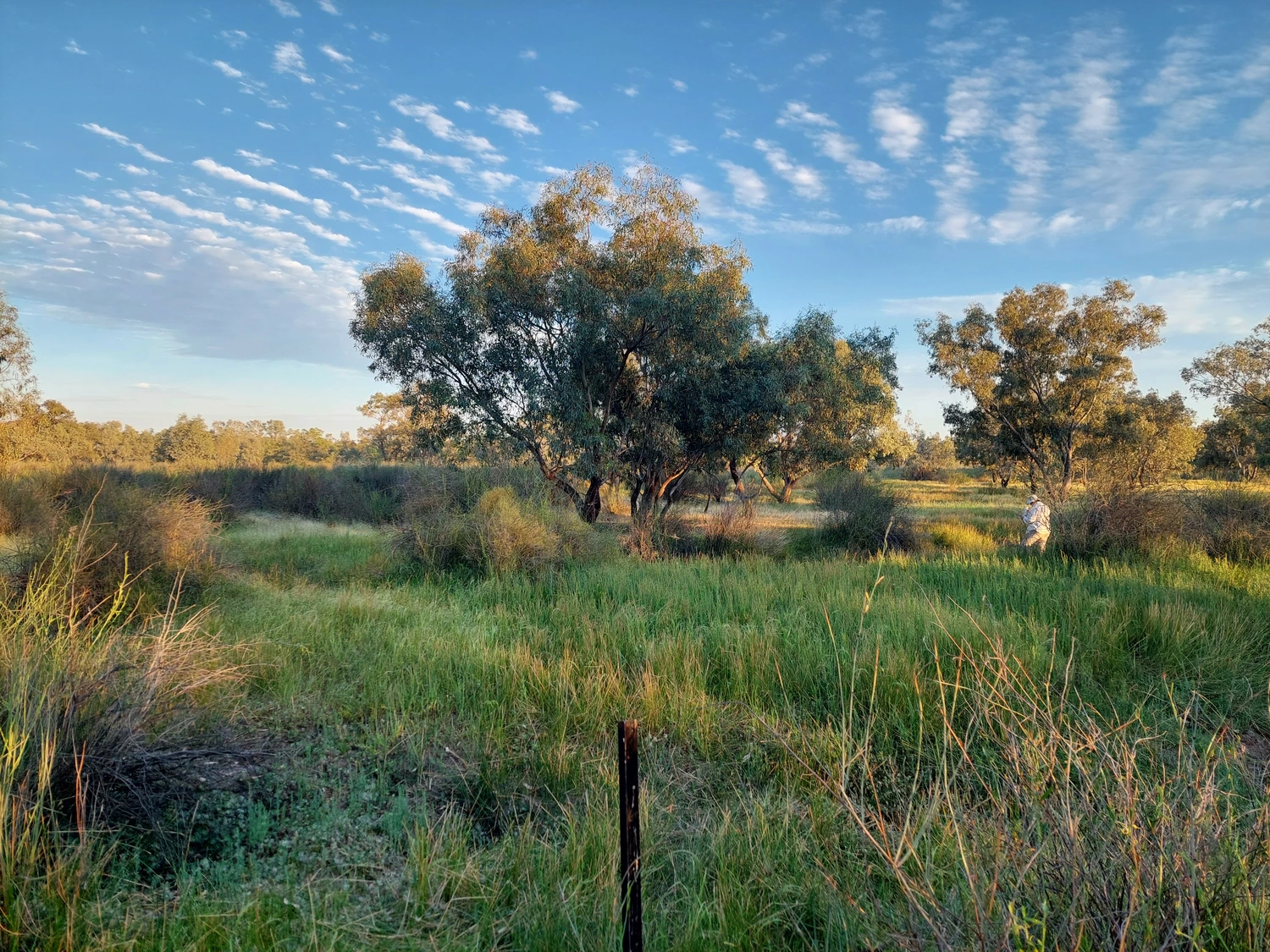
The waterways of the Darling (Baaka) and Warrego (Warriku) Rivers are important for native fish populations as they connect valuable floodplain and wetland sites. The Western Floodplain on the Warrego (Warriku) River and Menindee Lakes on the lower Darling (Baaka) are recognised as breeding and stopover grounds for local and migratory waterbirds.
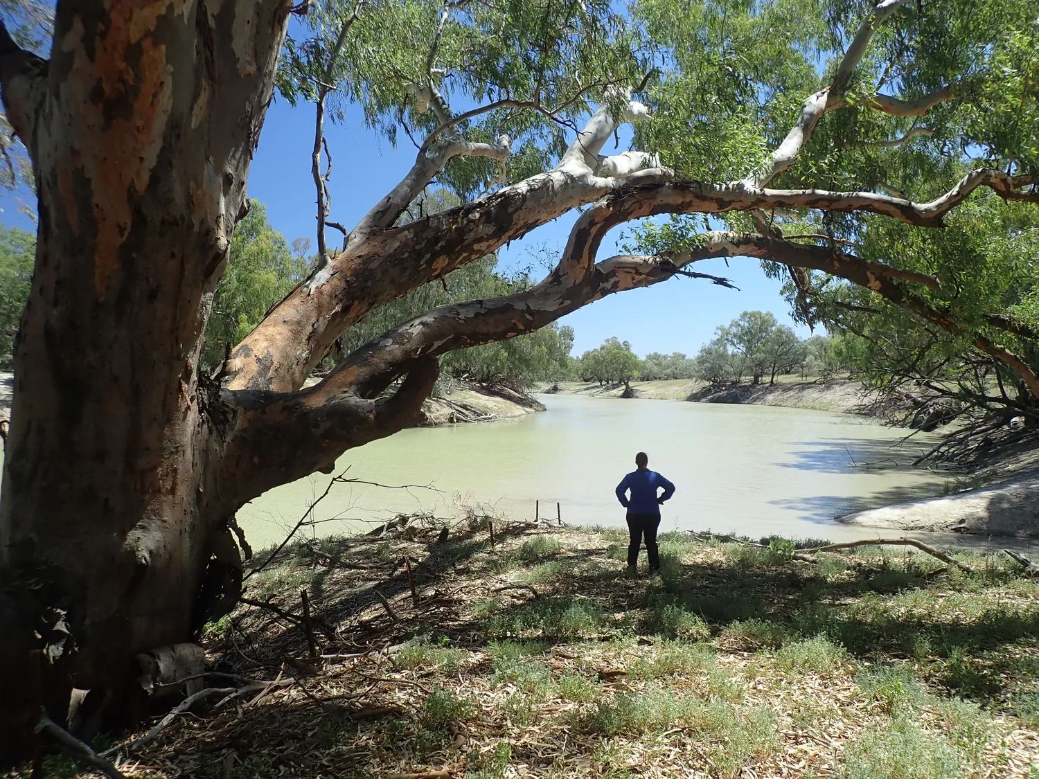
Flows in the Warrego (Warriku) River are mostly unregulated, whereas flows in the Darling (Baaka) are subject to significant regulation by dams, weirs and extraction. This changes the way in which water for the environment is managed in different parts of the systems.
In the Warrego (Warriku) River, environmental water is managed to improve connectivity to the Darling (Baaka), and to inundate the Western Floodplain in Toorale National Park (an important site for floodplain vegetation and waterbirds). In the Darling (Baaka) River, environmental water is managed to improve downstream connectivity and to support movement and breeding of native fish. In the lower Darling (Baaka) and Great Darling Anabranch, environmental water is also managed in the Menindee Lakes System to maintain water quality and support ecologically valuable vegetation communities, native fish and waterbirds. The Darling (Baaka) is a critical connectivity pathway, enabling native fish to move between the Basin’s north and south.
.webp)
Aerial image of Western Floodplain, Toorale National Park (Jan. 2025). Credit: University of New England
.webp)
Western floodplain, Toorale National Park (Jan. 2025). Credit: University of New England
.webp)
Black box woodland with shrubby understorey dominated by sticky hop bush and prickly wattle on the Western Floodplain, Toorale National Park (Jan. 2025). Credit: University of New England
Our Work
Learn about the key activities in this Area.

River Flows and Connectivity
The hydrological character of the Darling (Baaka) and Warrego (Warriku) River Systems influences the way Commonwealth environmental water flows through them. These flows are tracked and assessed using gauged hydrological data, satellite imagery, wetland extent mapping, depth logger information and field surveys. Of particular importance is the connectivity along and between rivers and their floodplains, providing access to vital breeding and feeding habitat for multiple species.
.webp)

Native Fish
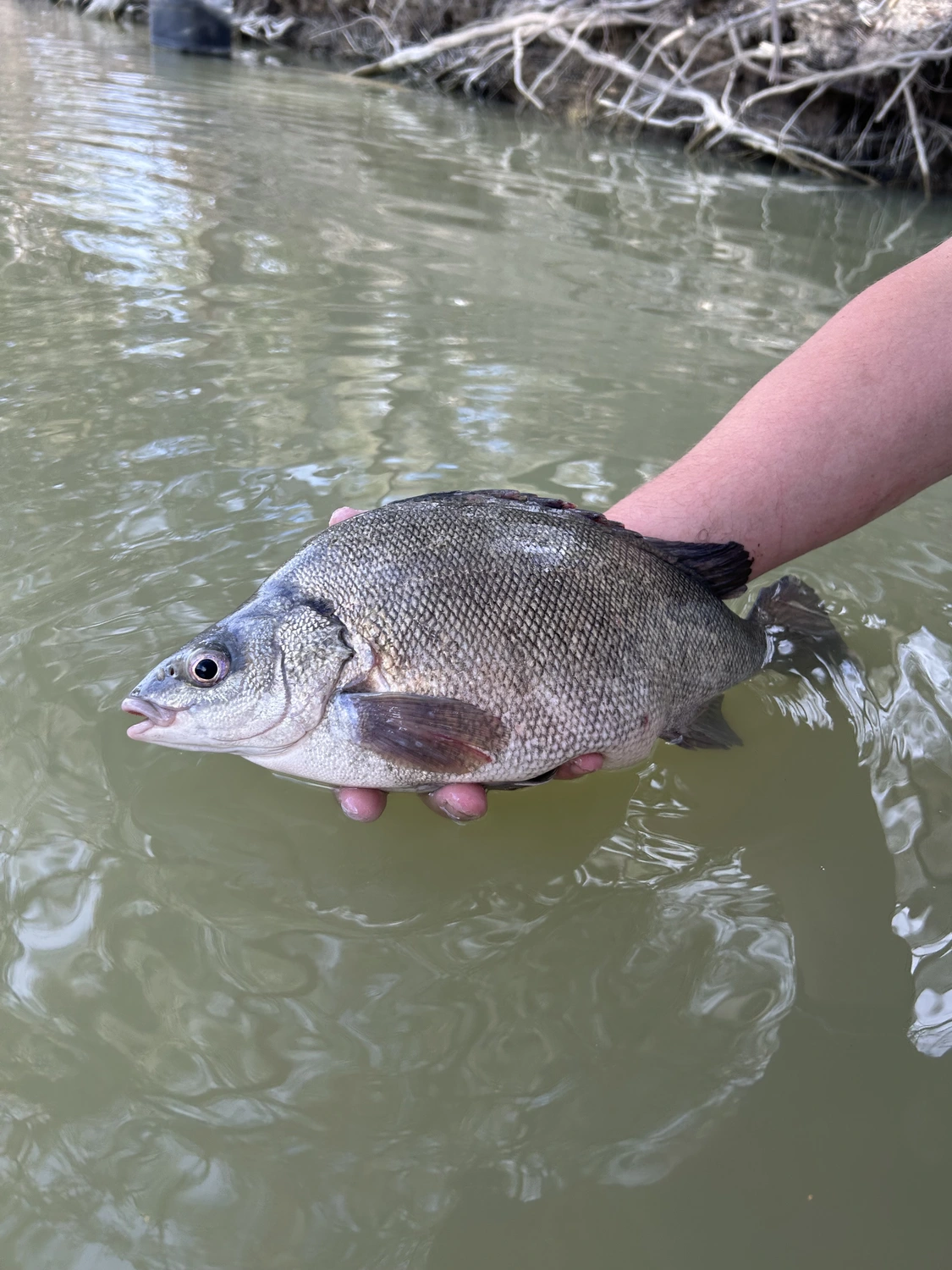
The Darling (Baaka) and Warrego (Warriku) River Systems are the largest and one of the most complex of the Murray-Darling Basin. Over the last 10 years, there have been numerous fish kills, devastating native fish populations. Monitoring fish community response to flow events is critical in understanding the response of fish across this region, so that connection between rivers and fish populations in the southern and northern MDB can be more holistically managed.

Waterbirds
Water for the environment is used in the Darling (Baaka)-Warrego (Warriku) River Systems to maintain core wetlands, and to ensure the successful completion of breeding and fledging cycles. Monitoring the abundance and diversity of waterbird communities occurs twice a year and additional monitoring is done in response to large-scale breeding events.


Native Vegetation
The vegetation communities of the wetlands and floodplains in the Darling (Baaka)-Warrego (Warriku) Systems are highly valuable ecological sites as they support landscape scale biodiversity. They provide breeding habitat, food and shelter for water-dependent species and are integral to overall ecosystem function. Monitoring of vegetation diversity in response to flooding occurs via annual surveys at key locations across a diverse range of plant community types.


Cultural outcomes and First Nations activities
With the guidance of our Cultural Advisor we will initially focus on engaging with First Nations people with connection to the Darling (Baaka) and Warrego rivers. We will understand how First Nations people want to be involved in the Flow MER Program and how the Program can benefit from their knowledge and science. We will work with First Nations people to identify cultural outcomes specific to their community and Country and how First Nations activities through the Program can support cultural outcomes.
_Tamara%20Kermode.avif)

Knowledge Exchange and Community Engagement
Our Community Engagement and Communication strategy aims to improve understanding, decision-making and environmental outcomes through a knowledge generation and sharing network based on trust, collaboration and meaningful relationships across the scientific community, government, stakeholders and local community. Communication and engagement are facilitated by meetings, presentations, workshops, forums, scientific papers, community news and storytelling, field days, citizen science events, websites and social media content.
%20Looking%20out%20from%20Mt%20Talowla_Tamara%20Kermode.avif)
Key Insights
River Flows and Connectivity
- Both the Darling (Baaka) and Warrego (Warriku) rivers experienced hot, dry conditions and periods of low flows early in the 2023-24 water year. As a result of these conditions, water quality deteriorated with some sites showcasing extreme conditions including very high total nutrient concentrations, severe algal blooms, supersaturated dissolved oxygen levels and high turbidity. During this time, the Western Floodplain was dry and did not support aquatic communities.
- The sustained flow event through the Warrego (Warriku) system that began on January 11, 2024, significantly improved water quality in the Warriku (Warrego). In the Darling (Baaka), connectivity with the Warrego (Warriku) River and increased flow during the second half of the 2023-24 water year played a crucial role in improving water quality in the Darling (Baaka) River.
.webp)
Darling (Baaka) River near the confluence with the Warrego (Warriku) River (Jan. 2025). Credit: University of New England
Native Fish
- Overall fish abundance continued to decline the Darling-Warrego (Baaka-Warriku) rivers in the last round of sampling in 2023-24, compared to numbers recorded in the 2021-22 water year.
- The fish community in 2023-24 continued to be dominated by common carp and detection of expected native species was very low. Recruitment among native species in 2023-24 was the lowest seen since monitoring began in 2015; and golden perch recruits were not recorded in the latest sampling round in either river.
- Some native species responded positively to flooding in 2023-24, and water for the environment can help sustain these natural events and support native fish communities.

The fish ladder at Homestead Dam on the Warrego (Warriku) River, Toorale National Park (May, 2024). Credit: Carmen Laidlaw, UNE.
Waterbirds
- Waterbird abundance and diversity were lower in 2023–24 than in earlier years when the much higher waterbird diversity and abundance (e.g. numbers in the multiple hundreds or thousands and twice as many species) were driven by inundation of the Western Floodplain (adjacent to the Warrego (Warriku) River).
- Water for the environment helped to sustain critical long-term waterbird refuge sites on Warrego (Warriku) River. As natural flows returned to the system, water for the environment strengthened those flows aiding in recharging the wetlands and floodplains of the Warrego-Darling (Warriku-Baaka) Rivers, encouraging waterbirds to congregate in greater numbers.

Credit: Pelicans, Western Floodplain, Toorale National Park (Nov. 2024) Dr Munique Reid, UNE.
Native Vegetation
- Core vegetation monitoring of sites in the northern sections of the Western Floodplain continues to identify strong links between inundation patterns and vegetation response.
- Species richness in 2023-24 was the lowest recorded in the ten years of monitoring across vegetation communities, even lower than during the drought in 2019. Flooding inundation in early-to-mid 2024 of lower-lying areas of the Western Floodplain and above-average rainfall increased vegetation cover.
- Patterns of vegetation response to inundation observed in previous years suggest that while species richness was low under dry and then inundated conditions, the 2024 flow contributed to greater species richness, cover and diversity of vegetation communities across the Western Floodplain because of the delivery of water for the environment. The resulting conditions will support the ecological function and maintenance of long-lived key woody floodplain species in the 2024-25 water year and beyond.

Lignum survey on the Western Floodplain, Toorale National Park (Dec. 2022). Credit: Dr David Mackay, UNE
Latest News
Annual reports, quarterly snapshots and implementation plans for the Darling and Warrego River Systems can be found on the Commonwealth Environmental Water Holder (CEWH) website.
News


Webinars
.avif)


Our Team
The University of New England has been engaged by the CEWH to conduct Flow-MER activities in the Darling and Warrego River Systems Area from July 2024 to June 2029.
University of New England

Partners

2Rog
NSW Government